วันเสาร์ที่ 28 พฤศจิกายน พ.ศ. 2552

Doi Tung - Chiang Rai / ดอยตุง - เชียงราย


Known by locals as Thailand’s Switzerland, Doi Tung (‘Flag Mountain') is an attractive mountain-top destination of forests and nearby Shan, Akha and Lahu tribal villages. Probably the most important attraction in the area is Wat Phrathat Doi Tung – a temple built one thousand years ago which is an important place of pilgrimage for Buddhists from Thailand and overseas. A giant flag was flown from the point where the temple’s chedis were built giving 'flag mountain' its name. Doi Tung is also home to the Doi Tung Development Project, an initiative of Her Royal Highness Srinakarindra the Princess Mother (mother of Thailand’s current monarch) who passed away in 1995.


Doi Tung has traditionally been an area at the centre of Thailand’s opium production, and with a ready supply of the drug in the area, drug use was prevalent, especially amongst the poor. The Princess Mother built a summer palace in the area and initiated the Doi Tung Development Project.


The purpose behind the project was to establish means of overcoming the area’s social problems through education, training, and through “Sustainable Alternative Development” such as changes in agriculture (an Agricultural Training Centre was set up to help people change from opium production to growing crops such as coffee, strawberries and macadamia nuts) and the introduction of trade in such items as local handicrafts (a ‘Cottage Industry Centre’ was also set up alongside an outlet for locally produced goods and to ensure local crafts such as hand carpet manufacturing are passed on to future generations.


The Princess Mother’s palace has been maintained exactly as it was when she stayed there. The grounds of the palace (Mae Fa Luang Garden) are extremely well kept and certainly warrant a visit. Visits to the Doi Tung Development Project’s various activities are also possible.


A trip to Doi Tung is often combined with a visit to Mai Sai. Probably the biggest draw to the region is its scenery. A trip through the mountains to Doi Tung is simply glorious. Hiking here is possible, but you should always arrange a guide – drug production does still exist and the Mong Thai Army and Karen Rebels are occasionally active in the area.


How to get there: The palace is located at kilometre 12 of route 1149. Given the distances to be covered and the fact a motor vehicle is essential to a trip to Doi Tung, an organised tour to the site is recommended.


Contact:
Doi Tung Development Project
(053) 767-003, (053) 767-015-7

วันอาทิตย์ที่ 15 พฤศจิกายน พ.ศ. 2552

San Kamphaeng Hot Spring - Chiang Mai / น้ำพุร้อนสันกำแพง - เชียงใหม่


San Kamphaeng Hot Spring, Chiang Mai is situated about 23 kilometers away from San Kamphaeng district and about 36 kilometers from the city. The spring is located in the scenic surrounding of the spectacular hills and in the shelter of the large and shady trees.


San Kamphaeng Hot Spring in Chiang Mai hosts a spectacular lush green park spread over an area of 40-acre.The park has been beautifully landscaped and it has a vast range of beautiful flowers. San Kamphaeng Hot Spring, Chiang Mai is opens from 8:00 in the morning till 4:30 in the evening.


The San Kamphaeng Hot Spring is one of the Chiang Mai Parks and Gardens which is an ideal place to go for picnics. The several facilities in the park include camping area, swimming pool, restaurant dining, mineral water bathing room huts and various other amenities.


If you are hungry you can also stop and eat something at the restaurant, ice-cream stand and other eating points dispersed throughout the premises of San Kamphaeng Hot Spring, Chiang Mai. People interested in sightseeing in Chiang Mai must visit this spring.


This place is the perfect destination for people who are conscious about their health and physical well being. The water at San Kamphaeng Hot Spring, Chiang Mai contains high sulphur content and it cures many diseases and improves blood circulation. The temperature of water at San Kamphaeng Hot Spring, Chiang Mai is around hundred degrees centigrade. The water comes from a deep source many attempts have been made to harness this energy but all had been in vain.


You can reach there by a local taxi which will cost you around 200 baht. Alternatively, you make take a Thailand Tourism - Chiang Mai Bus. It will cost 80 baht per person. The bus will leave for the Hot Spring at 10 am and it will head back to the town at 1 pm.


A short drive from San Kamphaeng Hot Spring will take you to another tourist attraction in Chiang Mai and it is the famous Bo Sang Umbrella Village. It is the place where you will come across an extensive range of handcrafted souvenirs. San Kamphaeng Hot Spring is one of the popular tourist destination in Chiang Mai that attracts numerous tourists every year and helps in promoting tourism in the city to a great extent

วันอาทิตย์ที่ 1 พฤศจิกายน พ.ศ. 2552

Doi Ang Khang - Chiang Mai - ดอยอ่างขาง - เชียงใหม่


The following is a list of mountains in Thailand. The altitudes are in metres. For the names of the mountains in the Roman script the Royal Thai General System of Transcription has been adopted.


Many mountains in the country are not important because of their height, but because of their symbolic and cultural significance. Some mountains have Buddhist worship places on top, like Doi Suthep close to Chiang Mai, while others have been adopted as provincial symbol, like relatively small Khao Sam Muk in Chonburi Province. Nevertheless, since the order of height is convenient, the list follows this order, without in any way intending to diminish or promote the importance of any particular mountain.


The Angkhang Nature Resort is the ideal base from which to explore the area. Visit the local hilltribes and the Royal Agricultural Project. Take a mule-ride up the hillside or for the more energetic hire a mountain bike to go exploring.

There are many walking trails around the resort. Nature lovers will notice many rare species of plant and birds in the surrounding countryside.


This remote mountainous region is located in upnorth Chiangmai. The vast area extends to the border of Myanmar and was once covered with hill evergreen forests. The heavy demand of cultivating land had led to the heavy deforestation and turned the dense woods to fruitlands and paddyfields. However, the natural altitudinal terrain of its 1,928 meter peak and the mingled biosphere of the remaining forests with deformed fruitlands has made Doi Ang Khang home of a myriad of resident and migrated birds. Birders from abroad seldom miss the chance to get there as the weather on the Doi (mountain) is pleasantly cool all year around and there are many superb birding trails.


Hume's Pheasant, Rufous-winged Buzzard, Black Eagle, Mountain Bamboo-Partridge, Golden-throated Barbet, Crimson-breasted Woodpecker, Bay Woodpecker, Rusty-naped Pitta, Short-billed Minivet, Long-tailed Minivet, Crested Finchbill Bulbul, Marron Oriole, Fire-capped Tit, Giant Nuthatch, Rusty-cheeked Scimitar-Babbler, Red-tailed Laughingthrush, Red-faced Liocichla, Spot-breasted Parrotbill, Daurian Redstart, Rufous-gorgetted Flycatcher, Slaty-blue Flycatcher, Black-headed Greenfinch, Little Bunting, Chestnut Bunting, etc.


During the winter, tourists like to travel to the Chaing Mai Province to camp and enjoy the blooming winter plants. Doi Ang Khang standing 1,900 meters above sea level, borders Burma and is located in Amphoe Chai Prakan.


The Road to Doi Ang Khang: While driving to Doi Ang Khang, you will see many multihued flowers adorning the roadside. However, the road here is steep and winding, so viewing should be left to the passengers.


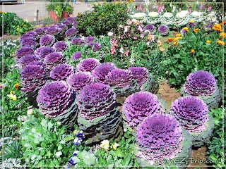
The Doi Ang Khang Royal Project: The Doi Ang Khang Royal Project is an agricultural station where they study horticulture. Here, in this fifty Rais (80,000 square meters) area, you will be able to see a vast array of indigenous and foreign plants.


The San KiewLom Viewpoint: From this viewpoint, you can overlook an ocean of fog in the morning, while the afternoons bring visions of villages and life below.


The Border Village: Three kilometers from the viewpoint is the Border Village. Here you can see the hill tribe people.